Trail Walking La Chapelle-Hareng - Chemin de la Fontaine au Dragon  -  La Chapelle-Hareng - Photo

Chemin de la Fontaine au Dragon - La Chapelle-Hareng

 tracegps
tracegps

User

© OpenStreetMap contributors
Length
Length
15.8 km
Max alt
Max alt
202 m
Uphill gradient
Uphill gradient
112 m
Km-Effort
Km-Effort  
17.3 km
Min alt
Min alt
169 m
Downhill gradient
Downhill gradient
114 m
Boucle
Boucle
Yes
Creation date :
2014-12-10 00:00:00.0
Updated on :
2014-12-10 00:00:00.0

(0 Reviews)

Walking
Walking
4h00
Difficulty : Difficult

Scan this QR Code to open this trail in the SityTrail application

FREE GPS app for hiking

Logo SityTrail SityTrail

IGN / Geographical institutes

Download SityTrail from the App Store Download SityTrail from Google Play

Logo SityTrail SityTrail World

The world is yours!

Download SityTrail from the App Store Download SityTrail from Google Play Download SityTrail on Huawei AppGallery

About

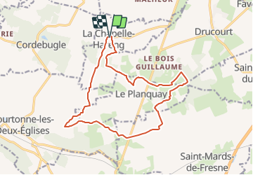
Trail Walking of 15.8 km to be discovered at Normandy, Eure, La Chapelle-Hareng. This trail is proposed by tracegps.

Description

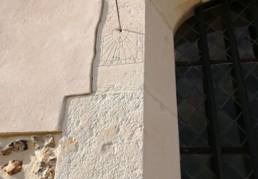
Circuit proposé par la Communauté de Communes du canton de Thiberville . Départ de l’église de La Chapelle-Hareng. A découvrir : l’église avec sa voûte du 16e siècle. Cadran solaire sue l’église, la mairie dans l’ancienne maison de la charité, la source de la rivière le Courtonnel. Ce circuit a été numérisé par les randonneurs du CODEPEM. Merci à Jean-Marie.

Elevation profile

Photos

Positioning

Country:
France
Region :
Normandy
Department/Province :
Eure
Municipality :
La Chapelle-Hareng
Location:
Unknown
Start:(UTM)
311317 ; 5443348 (31U) N.

Trails nearby

Trail Walking Barville - Barville - Photo
Walking
werth

Walking

Easy
(1)
Barville, Normandy, Eure, France
7.8 km | 8.7 km-effort
2h 5min
No
Trail Walking Courtonne-les-Deux-Églises - Courtonne les deux Eglises - Photo
Walking
Eve - Line

Walking

Medium
Courtonne-les-Deux-Églises, Normandy, Calvados, France
12.9 km | 15.6 km-effort
2h 43min
Yes
Trail Other activity La Chapelle-Hareng - La chapelle Hareng - Photo
Other activity
werth

Other activity

Very easy
(1)
La Chapelle-Hareng, Normandy, Eure, France
6.1 km | 7.1 km-effort
1h 40min
No
Trail Walking Valorbiquet - St Julien de mailloc - Photo
Walking
werth

Walking

Medium
Valorbiquet, Normandy, Calvados, France
7.9 km | 10.2 km-effort
2h 23min
Yes
Trail Walking Barville - Barville- 27 - Photo
Walking
Sylber

Walking

Easy
Barville, Normandy, Eure, France
8.8 km | 10 km-effort
2h 40min
Yes
Trail Walking La Chapelle-Hareng - chemin de la Baronniere - Photo
Walking
ymarvin

Walking

Easy
La Chapelle-Hareng, Normandy, Eure, France
6.6 km | 7.7 km-effort
1h 31min
Yes
Trail Walking La Chapelle-Hareng - Chemin de la Baronnière  -  La Chapelle-Hareng - Photo
Walking
tracegps

Walking

Easy
La Chapelle-Hareng, Normandy, Eure, France
6.3 km | 7.3 km-effort
1h 34min
Yes
Trail Walking Thiberville - Chemin des Housiaux  -  Thiberville - Photo
Walking
tracegps

Walking

Medium
Thiberville, Normandy, Eure, France
12.6 km | 13.4 km-effort
3h 10min
Yes
Trail Walking Barville - Chemin de la Fontaine  - Barville - Photo
Walking
tracegps

Walking

Medium
(1)
Barville, Normandy, Eure, France
8 km | 9 km-effort
2h 0min
Yes


Close
My subscriptions